Planning Application- Oxford Road
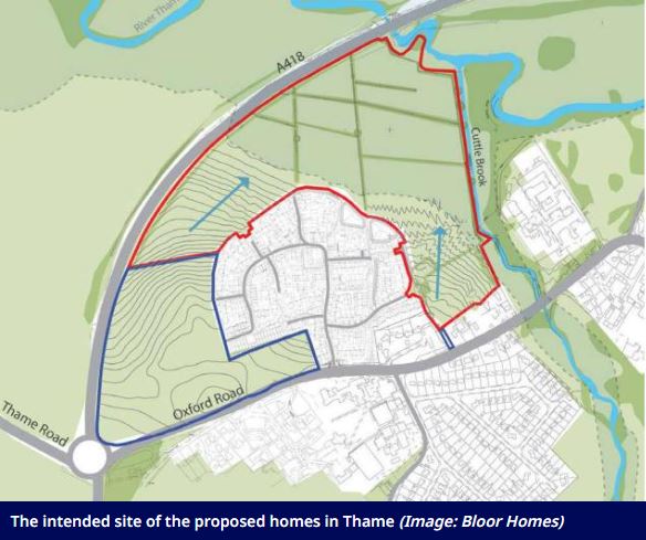
We are aware there is great concern regarding the planning application for 154 homes made at land off Oxford Road. The planning application will be considered by the Town and District Councils who will both consider matters such as open space, flood risk, housing needs and landscape and heritage issues, too. The Town Council does not have a date for consideration of this application, but as soon as we do, we’ll let residents know via our newsletter. Residents will be free to submit their own thoughts on the application via SODC’s website.
The Town Council is aware of concerns that the homes will be placed on land that floods. While the Town Council has yet to look at the application in great detail it is not believed that any of the proposed homes or gardens would be in any area at risk of river flooding.
Flood and drainage specialists from the Environment Agency and the District and County Councils will look closely at the current proposals just as they did for a similar application submitted in 2022. We note those experts were not worried at the time about the proposed new houses or gardens flooding. They were, however, very concerned about the risk the development could cause to land and property downstream through rainwater running off the site, should it be built. The developer will, therefore, have to prove that they can capture, store, and slowly release the water into our local streams and rivers at the same, or preferably lower rate, than it leaves the fields now.
The developer has provided detailed ground height surveys as part of their application to help identify areas at risk of river or surface water flooding. Residents can compare the applicant’s site plans for the housing with publicly available flood mapping. While the flood maps are not as detailed they should show any areas of concern:
Environment Agency Flood Risk maps can be viewed here.
A more detailed underlying map with the same information as above can be found here, although you will need to select “Flood Map for Planning / EA Flood Zone 2 and 3 to see them.